map
available

only on

desktop

harness the power of data
to stop future fisheries conflict
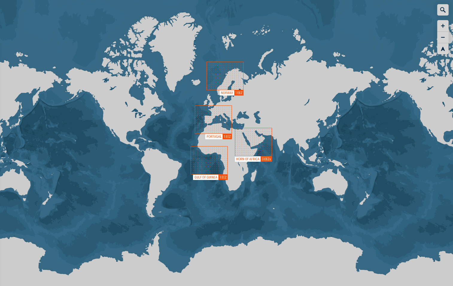
| ↗ EXPLORE ANALYSIS

Location name 0 EEZ

COUNTRY NAME MISSING (EEZ)
LOCATION NAME MISSING

RISK DATA MISSING FISHERIES
CONFLICT RISK IN 2030

Population

Human population size of the country in
2022. Data are from the United Nations
Population Division.

For more information please visit our
Methodology & Data page.

NO DATA
EEZ size

The area of a country’s exclusive economic zone,
according to the UN Convention on the Law of the Seas.
An EEZ defines the space over which a sovereign state has
exclusive rights over its marine resources, including fisheries.

For more information please visit our
Methodology & Data page.

NO DATA km2
Foreign Fishing Effort

Time spent actively fishing by vessels flagged to
a foreign nation, per square km of EEZ. Data are from
Global Fishing Watch.

For more information please visit our
Methodology & Data page.

NO DATA hrs/km2
Catch Trend

Change in fish catch, projected forward
five years. Data are from the Ocean Health Index.

For more information please visit our
Methodology & Data page.

undefined % change
Seafood Dependence

The amount of protein derived from seafood or
fisheries products compared to total animal-derived
protein consumed, per person. Data are from
the UN Food and Agriculture Organization.

For more information please visit our
Methodology & Data page.

NO DATA % daily protein intake
MPAs in EEZ

The percentage of area within an exclusive
economic zone containing a marine protected area.
Data are from the World Database on Protected Areas.

For more information please visit our
Methodology & Data page.

NO DATA
Disputed EEZ Border

The presence of a formally disputed international
maritime border in an exclusive economic zone.
Data are from the Marine Regions database.

For more information please visit our
Methodology & Data page.

NO
GDP per capita

The gross domestic product of a country,
per person. Data are from the International
Monetary Fund.

For more information please visit our
Methodology & Data page.

N/A
Militarized Fisheries
Conflicts

Incidents involving the deliberate, overt,
government-sanctioned, and government-directed
threat, display, or use of force between two or
more states over access to or control of fisheries
resources or policing of territorial waters and EEZs.
Data are from the Militarized Interstate Disputes
narratives as analyzed by Hendrix et al. 2022.

For more information please visit our
Methodology & Data page.

NO DATA
Historical Conflict
Intensity (Non-Fisheries)

Deaths due to events of organized violence
(phenomena of lethal violence occurring at a
given time and place), normalized by population.
Data are from the Uppsala Conflict Data Program.

For more information please visit our
Methodology & Data page.

Very low

Very high

NO DATA

Commercial fish composition

    NO DATA

    Climate Impact on Fisheries

    2020

    2020
    2030
    2040
    2050
    2060
    ADJUST CLIMATE SCENARIO. RCP

    RCP (Representative Concentration Pathways) are scenarios used to model potential future greenhouse gas concentrations. These pathways help predict and understand the impact of human activities on climate change, aiding in the assessment of various climate scenarios and their potential outcomes.

    10%

    Biomass

    -10%

    Use the +/- to zoom in and out of regions, or click any EEZ for details.